NWS: Upgrade to winter storm warning south of metro

It's the little things in life, isn't it?
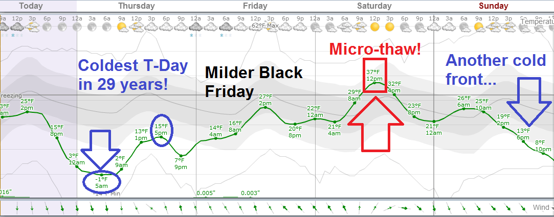
Warm socks. A friendly neighbor. Snow on the big travel day before the coldest Thanksgiving in 29 years.
Here's the latest on our pre-Thanksgiving winter weather event.
Create a More Connected Minnesota
MPR News is your trusted resource for the news you need. With your support, MPR News brings accessible, courageous journalism and authentic conversation to everyone - free of paywalls and barriers. Your gift makes a difference.
Winter weather advisories are in effect for snow until 6 p.m. this evening
Winter storm warnings have been issued for south central Minnesota
Snow of varying intensity today with slick roads and travel impacts
Snow tapers from northwest to southeast through the Twin Cities this afternoon
Snowfall of 1 to 3 inches likely central and east metro
Snowfall of 2 to 5 inches possible west and southwest metro
Heaviest snowfall totals from 4 to 10 inches south central Minnesota to near Minnesota River
Coldest Thanksgiving since 1985
Saturday thaw with temps in the mid-upper 30s

National Weather Service upgrades to winter storm warning south of metro
You could see this one coming. Snowfall of 8-plus inches has already fallen in Winnebago and parts of south central Minnesota. Here's the upgraded National Weather Service winter storm warning text.
INCLUDING THE CITIES OF...ST. PETER...MANKATO
857 AM CST WED NOV 26 2014
...WINTER STORM WARNING IN EFFECT UNTIL 6 PM CST THIS EVENING...
THE NATIONAL WEATHER SERVICE IN TWIN CITIES/CHANHASSEN HAS ISSUED A WINTER STORM WARNING FOR HEAVY SNOW...WHICH IS IN EFFECT UNTIL 6 PM CST THIS EVENING. THE WINTER WEATHER ADVISORY IS NO LONGER IN EFFECT.
* MAIN IMPACT...TRAVEL MAY BE DIFFICULT. EXPECT THE POSSIBILITY OF SIGNIFICANT DELAYS FOR THE BUSIEST TRAVEL DAY OF THE YEAR.
* SNOW ACCUMULATION...7 TO 10 INCHES.
* TIMING...SNOW HEAVY AT TIME THIS MORNING...TAPERING OFF THIS AFTERNOON.
The early radar returns confirm my thinking from yesterday. A potential snow bonanza is setting up along the Minnesota River centered on New Ulm, Mankato then over to Waseca and down to Amboy and Interstate 90 in south central Minnesota.
Heavier snow intensity was focused there this morning, and that's where the heaviest totals should end up. Here's the morning radar loop showing metro snow with "higher reflectivity" snow bands south. Check out the swirl -- a smaller vorticy pivoting south of Mankato pumping up snowfall intensity there.

Early snowfall totals support the heavy snow forecast to the south, with 6+ inches already down at Amboy south of Mankato...and an eye opening 8 inches down in Winnebago.
Mankato [Blue Earth Co, MN] BROADCAST MEDIA reports SNOW of 3.50 INCH at 7:40 AM CST --
mpxchat 2014/11/26 7:18 AM iembot
Amboy [Blue Earth Co, MN] TRAINED SPOTTER reports SNOW of 6.00 INCH at 7:05 AM CST --
mpxchat 2014/11/26 6:57 AM iembot
Mapleton [Blue Earth Co, MN] TRAINED SPOTTER reports SNOW of 4.00 INCH at 6:45 AM CST --
mpxchat 2014/11/26 6:31 AM iembot
Madelia [Watonwan Co, MN] TRAINED SPOTTER reports SNOW of 4.00 INCH at 6:30 AM CST --
Winnebago [Faribault Co, MN] CO-OP OBSERVER reports SNOW of 8.00 INCH at 8:00 AM CST --
The overnight runs from the National Oceanic and Atmospheric Administration's Global Forecast System seem to carry on yesterday's theme for a snow bull's-eye southwest of the metro. I can see a zone of 4 inches to as much as 8-plus inch totals south of the metro toward the I-90 corridor by this evening.

Snow tapers from northwest to southeast this afternoon, but slick travel will continue into this evening across southern Minnesota.
Roller coaster Thanksgiving Day weekend ahead
We plunge toward the coldest Thanksgiving in 29 years tomorrow, then claw back toward a Saturday micro-thaw before the next cold front sweeps south Sunday. Attention Target shoppers: Here's a detailed breakdown of the Thanksgiving holiday weekend.
Milder El Niño fueled pattern emerging in December?
It may be too early to bet the farm on this just yet, But I mentioned last week that Australia’s Bureau of Meteorology has raised the chances of El Niño to 70 percent, and raised the El Niño-Southern Oscillation level to "El Niño alert" status.
I'm already seeing a change in the upper air pattern that looks suspiciously like an El Niño driven jet stream -- a much more zonal Pacific flow setting up over the U.S. In fact the latest Global Forecast System runs are cranking out some seriously radical milder developing jet stream patterns over the U.S. as we move into December.
One overnight GFS run shoves the jet way north into Canada and develops an unseasonably warm (582-decimeter) ridge over Nebraska by around Dec. 11.

This may be overdone, but the GFS has been consistent for several runs now in developing unseasonable warmth over the central U.S. the past few days. This type of pattern would deliver a widespread thaw, and potentially some near record warm temperatures.
NOAA's Climate Prediction Center has latched onto the notion of warmer than average temps across a good chunk of the U.S. in the next two weeks.

If the pattern evolves, I could see an extended thaw with a string of 30s and possibly even some 40s for southern Minnesota at some point in the next two weeks.
Close to 50 degrees in southern Minnesota in December 2014?
Stay tuned.