Warm start to week; snow returns Tuesday
It was a March weekend, in January.
The official temp hit 40 degrees Sunday afternoon at Minneapolis-St. Paul International Airport. That's our average high temperature on March 13!
We typically top out at 24 degrees this time of year. I can see patches of my lawn poking through the shrinking snow cover, and very mild temps will stay with us as we start the week.
Highs in the mid to upper 30s will be common in Minnesota on Monday, with peeks of sun possible in the afternoon.
Create a More Connected Minnesota
MPR News is your trusted resource for the news you need. With your support, MPR News brings accessible, courageous journalism and authentic conversation to everyone - free of paywalls and barriers. Your gift makes a difference.
A few spots in southern Minnesota could hit 40 degrees.
Highs in the 30s are expected on Tuesday and Wednesday, then upper 20s on Thursday and Friday.
Snow returns Tuesday
The National Oceanic and Atmospheric Administration’s North American Mesoscale forecast model shows the potential snow pattern Tuesday and Tuesday night, as a low-pressure system passes to our south:
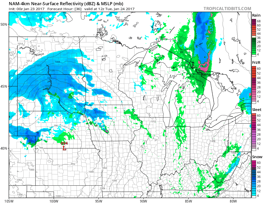
The color chart on the lower right of the loop refers to the strength of the radar signal returning to the radar, not inches of snow!
The snow will probably linger into Wednesday morning.
The heaviest snow is expected over far southern Minnesota, where 6 inches are possible. The National Weather Service has issued a winter storm watch for southern Minnesota Tuesday and Wednesday:

The Twin Cities metro area is not in the winter storm watch, but the metro is expected to see enough snow to shovel.
An early estimate would be 3 or 4 inches of snow in the metro area from Tuesday afternoon through midday Wednesday.
Here are details of the south-central Minnesota portion of the winter storm watch:
URGENT - WINTER WEATHER MESSAGE
NATIONAL WEATHER SERVICE TWIN CITIES/CHANHASSEN MN
858 PM CST SUN JAN 22 2017
...WINTER STORM TO IMPACT SOUTH CENTRAL MINNESOTA TUESDAY THROUGH
WEDNESDAY AFTERNOON...
.CONFIDENCE CONTINUES TO INCREASE IN THE POTENTIAL FOR
ACCUMULATING SNOW ACROSS THE SOUTHERN THIRD OF MINNESOTA AND WEST
CENTRAL WISCONSIN TUESDAY AFTERNOON INTO WEDNESDAY. THE HEAVIEST
AMOUNTS ARE FORECAST TO BE SOUTH OF THE MINNESOTA RIVER VALLEY
WHERE 5-7 INCHES ARE EXPECTED. SNOWFALL WILL BE HEAVIEST TUESDAY
EVENING WHEN SNOWFALL RATES OF 0.5-0.75" PER HOUR ARE POSSIBLE
ACROSS THE WATCH AREA. SNOW WILL MOVE EAST OF THE AREA BY
WEDNESDAY AFTERNOON BUT INCREASINGLY GUSTY NORTHWEST WINDS WILL
LEAD TO A THREAT FOR BLOWING AND DRIFTING SNOW. SNOW ON ROADS AND
LOW VISIBILITY FROM BLOWING & DRIFTING SNOW WILL MAKE FOR
DIFFICULT TRAVEL ACROSS SOUTHERN MINNESOTA AND MOTORISTS ARE
ADVISED TO USE CAUTION.
MNZ073>078-082>085-091>093-231100-
/O.CON.KMPX.WS.A.0002.170124T1800Z-170125T2100Z/
REDWOOD-BROWN-NICOLLET-LE SUEUR-RICE-GOODHUE-WATONWAN-BLUE EARTH-
WASECA-STEELE-MARTIN-FARIBAULT-FREEBORN-
INCLUDING THE CITIES OF REDWOOD FALLS, NEW ULM, ST PETER,
LE SUEUR, FARIBAULT, RED WING, ST JAMES, MANKATO, WASECA,
OWATONNA, FAIRMONT, BLUE EARTH, AND ALBERT LEA
858 PM CST SUN JAN 22 2017
...WINTER STORM WATCH REMAINS IN EFFECT FROM TUESDAY AFTERNOON
THROUGH WEDNESDAY AFTERNOON...
* TIMING...TUESDAY INTO WEDNESDAY AFTERNOON
* MAIN IMPACT...ACCUMULATING SNOW WILL MAKE FOR DIFFICULT TRAVEL
* OTHER IMPACTS...BLOWING AND DRIFTING SNOW WITH LOW VISIBILITIES POSSIBLE
WEDNESDAY
PRECAUTIONARY/PREPAREDNESS ACTIONS...
A WINTER STORM WATCH MEANS THERE IS A POTENTIAL FOR SIGNIFICANT
SNOW...SLEET...OR ICE ACCUMULATIONS THAT MAY IMPACT TRAVEL.
CONTINUE TO MONITOR THE LATEST FORECASTS.
NOAA's forecast plume shows the range of Minneapolis snow forecasts from different versions of forecast models:

The models give Minneapolis snow totals ranging from less than 1 inch on the low end to about 8 inches on the high end.
The average of the various models (thick black line) is about 3 inches.
We'll keep you updated as new forecast info arrives.