Snow tapers off today; a very cold front arrives on Tuesday
You could say that we woke up to a winter wonderland.
Snowfall amounts by daybreak today were in the 1-2 inch range across much of eastern Minnesota.
The Twin Cities area could see another half inch or so of snow this morning, then we'll have a chance of occasional rain or snow showers this afternoon.
Heavier snow amounts are expected this morning and early afternoon over southeastern Minnesota, and accumulating snow will continue through this afternoon in much of north-central and northeastern Minnesota.
Create a More Connected Minnesota
MPR News is your trusted resource for the news you need. With your support, MPR News brings accessible, courageous journalism and authentic conversation to everyone - free of paywalls and barriers. Your gift makes a difference.
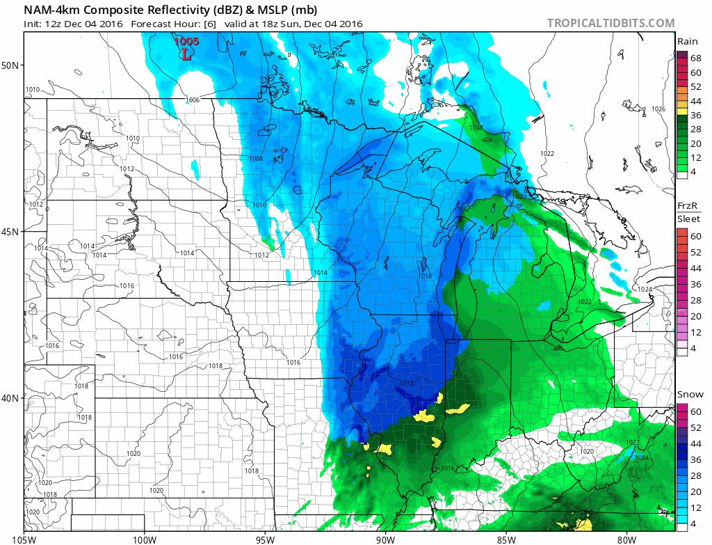
Here's the simulated radar for this afternoon, from NOAA’s 4km resolution North American Mesoscale forecast model:
Advisories
The La Crosse, WI office of the National Weather Service has issued a winter weather advisory that is effect until noon today for southeastern Minnesota and southwestern Wisconsin:

Here are more details, from the NWS:
URGENT - WINTER WEATHER MESSAGE
NATIONAL WEATHER SERVICE LA CROSSE WI
315 AM CST SUN DEC 4 2016
...SNOW CONTINUES TODAY...HEAVIEST THROUGH THE MORNING HOURS...
.SNOW HAS OVERSPREAD THE AREA EARLY THIS MORNING...WITH AMOUNTS SO
FAR RANGING FROM JUST A DUSTING NEAR THE I-94 CORRIDOR TO AS MUCH
AS A HALF INCH ACROSS NORTHERN IOWA AND EASTERN MINNESOTA. SNOW IS
EXPECTED TO PICK UP IN INTENSITY THIS MORNING...WITH ADDITIONAL
ACCUMULATION OF 1 TO 5 INCHES...HIGHEST ACROSS WESTERN WISCONSIN
INTO NORTHERN AND EASTERN IOWA. SNOW WILL TAPER OFF FROM EAST TO
WEST THROUGH LATE AFTERNOON.
WHERE SNOW HAS OCCURRED OVERNIGHT...ROADS ARE SNOW COVERED AND
SLICK...PARTICULARLY SECONDARY AND NEIGHBORHOOD ROADWAYS. SLICK
TRAVEL CONDITIONS WILL CONTINUE THROUGH THE MORNING HOURS TODAY AS
SNOW CONTINUES TO ACCUMULATE. PLEASE SLOW DOWN AND ALLOW EXTRA
TIME TO SAFELY REACH YOUR DESTINATION.
IAZ009-010-018-019-029-MNZ088-095-096-WIZ032-041715-
/O.CON.KARX.WW.Y.0014.000000T0000Z-161204T1800Z/
HOWARD-WINNESHIEK-FLOYD-CHICKASAW-FAYETTE-WINONA-FILLMORE-HOUSTON-
BUFFALO-
INCLUDING THE CITIES OF...CRESCO...DECORAH...CHARLES CITY...
NEW HAMPTON...OELWEIN...WINONA...PRESTON...CALEDONIA...ALMA
315 AM CST SUN DEC 4 2016
...WINTER WEATHER ADVISORY REMAINS IN EFFECT UNTIL NOON CST
TODAY...
* PERIODS OF SNOW WILL CONTINUE THIS MORNING...ENDING QUICKLY
AFTER NOON TODAY.
* THE HEAVIEST SNOWFALL RATES WILL OCCUR BETWEEN 6 AM AND NOON.
* TOTAL SNOW ACCUMULATION OF 2 TO 4 INCHES IS EXPECTED...WITH
LOCALIZED AMOUNTS OF 5 INCHES POSSIBLE OVER NORTHEAST IOWA.
* LOOK FOR REDUCED VISIBILITIES AT TIMES.
* PLAN ON SLIPPERY ROAD CONDITIONS.
PRECAUTIONARY/PREPAREDNESS ACTIONS...
A WINTER WEATHER ADVISORY MEANS THAT PERIODS OF SNOW WILL CAUSE
TRAVEL DIFFICULTIES. BE PREPARED FOR SLIPPERY ROADS AND LIMITED
VISIBILITIES...AND USE CAUTION WHILE DRIVING. THE LATEST ROAD
CONDITIONS FOR THE STATE YOU ARE CALLING FROM CAN BE OBTAINED BY
CALLING 5 1 1.
And a summary, from the NWS:

The snow will continue through the afternoon over much of central and southern Wisconsin, where winter weather advisories are also in effect.
The NWS Duluth office has issued a winter weather advisory that runs until 6 p.m. today for parts of northeastern Minnesota, near the north shore of Lake Superior:

Details of the advisory, from the NWS:
URGENT - WINTER WEATHER MESSAGE
NATIONAL WEATHER SERVICE DULUTH MN
824 AM CST SUN DEC 4 2016
...SNOW FOR THE MINNESOTA NORTH SHORE TODAY...
.LIGHT TO MODERATE SNOW WILL DEVELOP THIS MORNING AND CONTINUE
THROUGH MUCH OF THE DAY. SNOWFALL FROM 3 TO 6 INCHES IS EXPECTED
THROUGH THIS EVENING...WITH THE HIGHEST AMOUNTS ALONG THE HIGHER
TERRAIN NEAR LUTSEN...GRAND MARAIS...AND GRAND PORTAGE. AREAS
ALONG THE IMMEDIATE SHORELINE WILL GET THE LIGHTER AMOUNTS. THERE
COULD BE BRIEF PERIODS OF LOW VISIBILITY ALONG HIGHWAY 61 BECAUSE
OF STRONG SOUTHERLY FLOW COMING OFF LAKE SUPERIOR. THE SNOW WILL
TAPER OFF FROM WEST TO EAST THIS EVENING.
MNZ020-050000-
/O.EXB.KDLH.WW.Y.0019.161204T1424Z-161205T0000Z/
SOUTHERN LAKE/NORTH SHORE-
INCLUDING THE CITIES OF...TWO HARBORS...SILVER BAY
824 AM CST SUN DEC 4 2016
...WINTER WEATHER ADVISORY IN EFFECT UNTIL 6 PM CST THIS
EVENING...
THE NATIONAL WEATHER SERVICE IN DULUTH HAS ISSUED A WINTER
WEATHER ADVISORY FOR SNOW...WHICH IS IN EFFECT UNTIL 6 PM CST
THIS EVENING.
* LOCATIONS...TWO HARBORS...SILVER BAY...AND ALONG THE HIGHER
TERRAIN OF THE NORTH SHORE.
* TIMING...THROUGH THIS AFTERNOON. THE GREATEST SNOWFALL RATES
WILL BE LATE THIS MORNING THROUGH THE MIDDLE OF THE AFTERNOON.
* SNOW ACCUMULATIONS...2 TO 5 INCHES.
* VISIBILITY...ONE-HALF MILE AT TIMES...BUT GUSTY WINDS OFF LAKE
SUPERIOR...COMBINED WITH HEAVIER SNOW BURSTS...COULD DROP
VISIBILITY TO ONE-QUARTER MILE ALONG PORTIONS OF HIGHWAY 61.
* IMPACTS...THE SNOW COULD CAUSE TRAVEL DIFFICULTIES.
PRECAUTIONARY/PREPAREDNESS ACTIONS...
A WINTER WEATHER ADVISORY FOR SNOW MEANS THAT ACCUMULATING SNOW
WILL CAUSE TRAVEL DIFFICULTIES. BE PREPARED FOR SNOW COVERED
ROADS AND REDUCED VISIBILITY...AND USE CAUTION WHILE DRIVING.
ALLOW EXTRA TIME TO REACH YOUR DESTINATION.
Mild temps today and Monday
Highs today will range from the lower 30s over northern Minnesota to the upper 30s in the southwest:

Far southern Minnesota could touch 40 degrees on Monday:

We'll see falling temps on Tuesday, and our afternoon highs on Wednesday will be in the upper teens to around 20.
It'll be windy across Minnesota Tuesday and Wednesday, so wind chill temps Tuesday night and Wednesday could drop below zero!
Programming note
You can hear my live weather updates on Minnesota Public Radio at 7:35 a.m. and 4:35 p.m. each Saturday and Sunday.