Periods of rain this afternoon through Friday
April showers bring May flowers.
Why isn't there a saying about March showers?
Maybe we should have a contest.
Rain moves in
Create a More Connected Minnesota
MPR News is your trusted resource for the news you need. With your support, MPR News brings accessible, courageous journalism and authentic conversation to everyone - free of paywalls and barriers. Your gift makes a difference.
A low-pressure system will move slowly eastward from the Rockies the next couple of days. It will spread rain into Minnesota this afternoon and evening. Periods of rain are expected overnight tonight, and northeastern Minnesota could also see some freezing rain and sleet.
On Friday and Friday night, periods of rain are expected over central and southern Minnesota.
The National Oceanic and Atmospheric Administration’s North American Mesoscale forecast model shows the potential precipitation pattern:

Here are NOAA's NAM forecast model precipitation totals from this afternoon through Saturday morning:
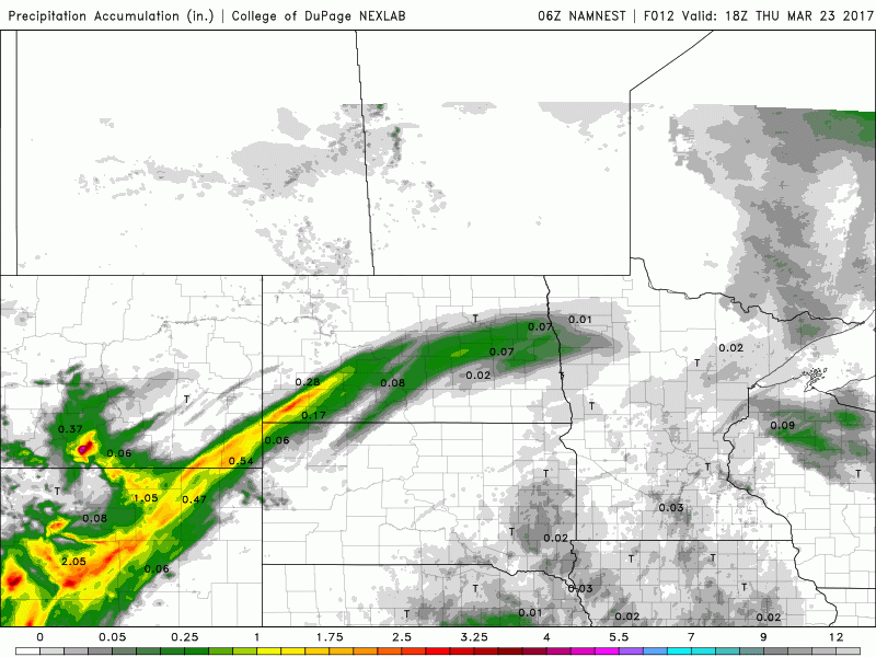
Areas in yellow indicate one inch or more of rain from late Thursday afternoon through Saturday morning. Orange and red areas have the potential for two or more inches of rain.
The highest rain totals are expected in southern Minnesota and parts of western Wisconsin.
Thunderstorm chance
Minnesota could also see some scattered thunderstorms late Thursday afternoon into Thursday night.
The Storm Prediction Center of the National Weather Service has a marginal risk of severe weather for southwestern Minnesota later this afternoon into Thursday night:

Marginal risk means that an isolated severe thunderstorm is possible:
Temps don't move much
Our Thursday afternoon high temps will be in the lower 40s over most of Minnesota, with some upper 30s in the northeast.
On Friday, most of Minnesota will see highs in the 40s:

Highs this weekend will be similar to our Friday high temps, with upper 40s in southern and central Minnesota; 50s return to southern Minnesota on Monday.
Low on the snow
The Twin Cities metro area is running 18.5 inches below normal on our season snowfall total right now. Duluth is 11.8 inches below normal at this point in their snow season.
A couple of snowstorms ducked south of the Twin Cities metro area this year, and hit southern Minnesota. That's why Rochester has 6 inches more snow than normal for its 2016-2017 snow season.
Programming note
You can hear my live weather updates on Minnesota Public Radio at 7:49 a.m. Thursdays and Fridays, and at 7:35 a.m. and 4:35 p.m. each Saturday and Sunday.