Higher Flood Forecast: 8th highest for Mississippi in St. Paul? Anatomy of runoff
Friday's flood forecast numbers are moving higher for some rivers. That includes the Mississippi River in St. Paul where the water is rising quickly now.

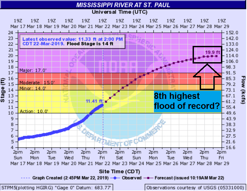
The updated flood forecast numbers now estimate the Mississippi River will reach 19.9 feet in St. Paul by next Friday.
That level would mark the eighth highest flood of record on the Mississippi at St. Paul — the highest in nearly five years.

Minnesota River running higher
Create a More Connected Minnesota
MPR News is your trusted resource for the news you need. With your support, MPR News brings accessible, courageous journalism and authentic conversation to everyone - free of paywalls and barriers. Your gift makes a difference.
Upstream, the Minnesota River is running fast. Snowmelt acceleration is driving water higher.
And there's still plenty of snow to melt in western and northern Minnesota.
There's still anywhere from 2 to 8 inches of water content in the snow across western Minnesota. It's more like 12 inches above the North Shore.
Here's the latest snow depth analysis from the National Oceanic and Atmospheric Administration:

The Minnesota River is forecast to reach within a foot of the flood record at Morton, Minn., next week.

At Henderson, Minn., the latest hydrologic models predict the water level to be within 1.5 feet of the record flood next week.

That big bubble of water flowing down the Minnesota River is heading for the Mississippi at Fort Snelling. That's one reason flood forecasts are moving higher.
And the rivers are likely to stay high for several weeks this spring. That means rivers will be vulnerable to heavy rain systems in the coming weeks.
I spoke with Brent Hewitt Friday at the Twin Cities National Weather Service office. Here's his perspective on the latest hydrologic factors and the higher river forecast trends.
We are still benefiting from the timing of the snow melt in the major basins. The melt has been very efficient over the past week with most of the melt water running off into the river basins.
This is giving locations like St. Paul and downstream a slightly higher forecast than initially thought (still at major flood stage, but not in the 1965 record realm).
The river forecast models ingest new data as our forecasts update and evolve. Fluctuations with the forecast heights will still occur as we receive new information each day.
We will, however, keep running very high for a long period of time, probably through April.
This leads to the second main point...we are VERY VULNERABLE to any heavy rainfall events for the next 4 to 6 weeks. Soils will be saturated, river levels higher than normal, and no crops in the fields.
Any significant rains through at least April (and even into May) could cause a much higher flood than would ordinarily occur."
The St. Croix River at Stillwater, Minn., will begin to respond rapidly next week as the snow melts farther north.

Anatomy of runoff
So how do daily weather conditions impact runoff?
It's easy to see how our freeze-thaw pattern this week is impacting runoff rates.
Here's a look at creek levels on Minnehaha Creek. You can see runoff pulses with higher rates during the afternoon and evening, then lower levels as things freeze up at night. Overall runoff rates are moving higher this week as we've warmed up.

A shot at 60 degrees next week
The good news for flood forecasters and river levels is there is little rain in the forecast next week. Some spotty showers may roam across southern Minnesota Sunday.
Rain chances late next week do not look as heavy as they did yesterday.
But temperatures spike next week. Highs in the 60s look more plausible in southern Minnesota. The warm air next week will supercharge snowmelt in western and northern Minnesota.

Bottom line: Flood impacts will increase dramatically over the next 72 hours in southern Minnesota as rivers rise steadily. Many rivers will reach Top 10 floods of record next week. Stay tuned.