El Nino blow torch winter of 2015-16?
Welcome to "meteorological winter."
If December's opening salvo is a sign of the coming winter, buckle up for some unusual and perhaps unprecedented events in the next 3 months.
Case in point? Our first real snowfall of the season ranged from funky for many, to just plain weird for some. Heavy wet cement-like snow? Sputtering stop-and-start snow bands over the metro? Lake-effect rain in Duluth?
What next, Locusts?
Create a More Connected Minnesota
MPR News is your trusted resource for the news you need. With your support, MPR News brings accessible, courageous journalism and authentic conversation to everyone - free of paywalls and barriers. Your gift makes a difference.
Snow winds down in northern Minnesota into Wednesday morning. Expect some slick roadways up north into early Wednesday.
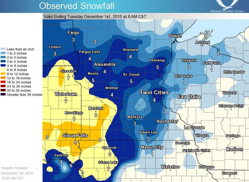
Storm warp: Snowfall totals
The system dropped impressive snowfall totals in southwest Minnesota, and less snow than forecast over the Twin Cities as the lack of Arctic air made it tough for this system to become an efficient snow producer.

Warm air near metro
Warm air slightly above freezing worked into the east side of the storm near the Twin Cities. That produced more mixed precip than the bulk of the forecast models suggested, and made for a less efficient snow crystal producer. With temps just above freezing and warm ground, some snow melted on contact. Snowfall forecasts were spot on for southwest Minnesota, but a few inches too high for the metro. A metro bust? Not exactly given the storm's impacts, but a serious bend for sure. Here's a nice comparison of forecast vs. actual snowfall from the Twin Cities NWS.

2015-16: Year without a real winter?
A month ago, I went out on a big limb and predicted winter temperatures overall would average 4 to 8 degrees warmer than average across Minnesota. I'm beginning to wonder if I crawled out far enough on that limb. This looks like the 2nd warmest meteorological fall (Sep-Nov) on record across Minnesota. November is in the books as the 4th warmest on record. At 7.6 degrees warmer than average, November 2015 was a full 16 degrees warmer than last year. That's an unprecedented year to year variation.
I'm beginning to see trends that suggest this may be a highly unusual, even unprecedented winter for Minnesota and perhaps much of the United States. The jet stream patterns I'm looking at already fit perfectly with the usual pattern in strong El Nino winters. All longer term climate indications point to a much warmer than average December. NOAA's 8-14 day temp outlook favors much milder than average temps for most of the US. An 80% chance of milder than average temps from Minnesota to the east coast next week?

Now, the early products from NOAA's Climate Forecasting System (CFSv2) for January are painting another scenario of extreme winter warmth.
Based on forecast trends I can anticipate some of the following unusual to unprecedented scenarios developing for this winter season in Minnesota.
Unusually late, perhaps record late "ice-in" dates for many lakes in Minnesota and the Upper Midwest.
Extensive thin and unsafe ice on lakes this winter.
A much higher than average number of cars, snowmobiles and (hopefully not) people going through thin ice this winter.
Possible postponement, location shifting or cancellation of lake-based winter events.
Unusually shallow frost depth in many locations.
Inability to maintain consistent snow cover in many locations.
At this early point in winter, signs suggest the record El Nino blow torch may be about to blow this winter.
Stay tuned.