Spotty showers today, stormy May ahead?

The calendar turns to May Friday. Our droughty weather pattern appears ready to change too.
A wetter and stormier May weather pattern appears to be developing for the Upper Midwest. That could be good news for easing drought in Minnesota. Rivers and lakes are low, and a few inches of rain would provide a boost to water levels and dry soils.
2.89 inches: 16-day forecast rainfall total for Minneapolis-St. Paul International Airport from the National Oceanic and Atmospheric Administration's Global Forecast System.
Create a More Connected Minnesota
MPR News is your trusted resource for the news you need. With your support, MPR News brings accessible, courageous journalism and authentic conversation to everyone - free of paywalls and barriers. Your gift makes a difference.
In the short run, today's showers will be on the spotty and lighter side. Look for scattered afternoon showers, with rainfall totals generally under one-tenth of an inch across Minnesota.

A smudge of clouds slides across Minnesota today with the weak passing cool front. Sunshine and near perfect spring weather returns Wednesday and Thursday. The next chance for showers arrives Friday.
Here's a more detailed breakdown for the rest of the work week.

June preview weekend
April was the new May this year. We've already enjoyed seven days at or above 70 degrees this month at MSP Airport. We may add another before month's end. The first weekend of May will feel more like June.
Saturday features plenty of sun and temps soaring into the upper 70s. Some Minnesota towns could touch 80 Saturday afternoon. Saturday night and Sunday could bring the first significant thunderstorm outbreak of the season.
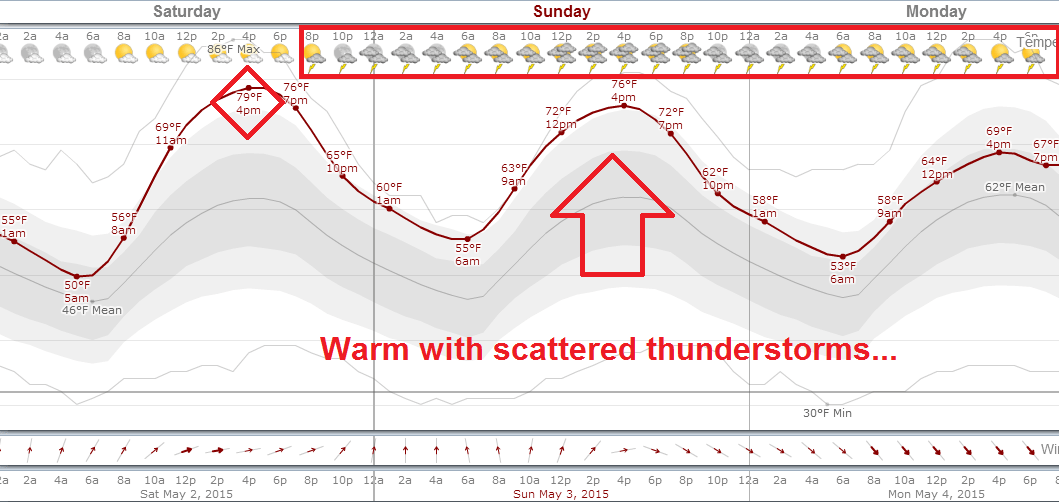
Scattered thunderstorms could arrive as early as Saturday night. The best chance for storms with heavy downpours appears to be Sunday evening.

You will notice the humidity levels creeping up Sunday. Dew points should approach 60 degrees by Sunday evening. Preview of coming attractions this summer?

It's too early to be precise about location, but some of the storms should pack (welcome) heavier rainfall totals that could approach an inch somewhere in southern Minnesota.
The heaviest rain swath looks to fall (just) south of Minnesota. But it's moving closer.
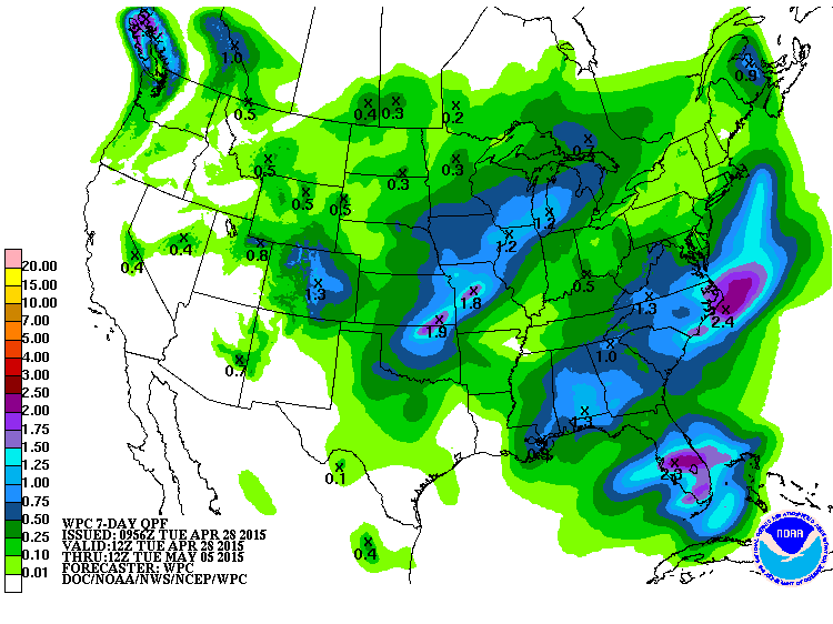
Here's NOAA's 16-day rainfall output for MSP. Focusing on precise rainfall totals this far out is usually a fool's errand, but the numbers can be revealing when looking at forecast trends. Bottom line? our chances for meaningful, soaking rains (and potentially strong storms) go up starting next weekend.

Stay tuned.