A bright and pleasant Sunday, followed by a rainy Memorial Day
You'll like our Sunday weather, and I'm really glad that it's happening on a weekend. Rain is in the forecast for much of Minnesota on Memorial Day.
On to the details.
Temperature trends
Sunday afternoon highs will reach the 70s across most of Minnesota and western Wisconsin. There will be some 60s in far northern Minnesota, and possibly some upper 50s near the Canadian border.
Create a More Connected Minnesota
MPR News is your trusted resource for the news you need. With your support, MPR News brings accessible, courageous journalism and authentic conversation to everyone - free of paywalls and barriers. Your gift makes a difference.
Memorial Day highs will be mainly in the 60s, with some 50s from central Minnesota northeastward:
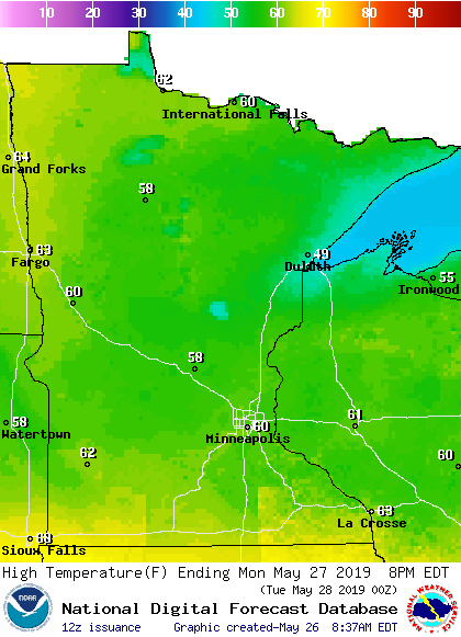
Some spots near Lake Superior might only reach the upper 40s.
Twin Cities metro area highs are projected to be around 70 degrees Tuesday and Wednesday, followed by lower 70s Thursday and mid 70s on Friday.
Rain and thunder chances
Most of us won't see any rain this Sunday.
Northwestern Minnesota will have a chance of some scattered showers today. That shower chance spreads into north-central Minnesota by late afternoon and northeastern Minnesota by this evening.
Some showers and thunderstorms are expected to move into southwestern Minnesota after midnight Sunday night and spread northeastward. They could arrive in the Twin Cities metro area before sunrise on Monday. Periods of rain with some embedded thunderstorms are likely on Memorial Day across about the southern half of Minnesota, plus much of western Wisconsin. Northern Minnesota could see some scattered showers.
The National Oceanic and Atmospheric Administration’s North American Mesoscale forecast model shows the potential rain pattern Sunday afternoon through Monday evening:

The color chart to the right of the loop refers to the strength of the signal that returns to the radar, not to the amount of rain. It will rain in some areas that look dry in the NAM loop, but the loop illustrates the general rain pattern.
As always, updated weather information can be heard on the Minnesota Public Radio Network, and you’ll also see updated weather info on the MPR News live weather blog.
The Storm Prediction Center of the National Weather Service shows a marginal risk of severe weather Monday and Monday night in portions of far southern Minnesota:

Marginal risk means that an isolated severe t-storm is possible. There will be a higher chance of severe weather in Iowa tomorrow.
Flooding concerns
Many locations in southern Minnesota could see 1 to 2 inches of rain on Monday, with additional rain Tuesday afternoon into early Wednesday.
The rain could cause some flooding:

River levels are rising
Recent rainy weather has caused river levels to rise again across much of southern Minnesota, and rivers have reached flood stage at many locations.
You can click on any location on the NWS Advanced Hydrologic Prediction Service (AHPS) site to get hydrographs of recent and forecast river levels. Some locations list levels in feet above sea level, others list levels in feet above a local reference point.
Here’s the Sunday morning hydrograph for the Mississippi River at St. Paul:

You can see that the Mississippi River is expected to reach flood stage at the St. Paul location Sunday afternoon and keep rising until late Tuesday.
The lower portions of some trees on the eastern side of Raspberry Island were under water Sunday morning:

There are flood warnings along some rivers in Minnesota. You can get flood warning updates by clicking on any green-shaded location on the National Weather Service Twin Cities website.
Here’s how the NWS map looked Sunday morning:

Projected river levels are updated on a regular basis, so check back to the AHPS site and the National Weather Service point forecasts for the latest info on the rivers near you.
If you’d like to scroll through hydrographs along a certain river in central or southern Minnesota, check here.
Programming note
You can hear my live weather updates on Minnesota Public Radio at 7:49 a.m. Thursdays and Fridays, and at 7:35 a.m., 9:35 a.m. and 4:35 p.m. each Saturday and Sunday.